
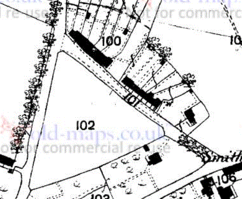
The Green on the 1842 Tithe Map (north is to the left)
A Whiteparish local history page from younsmere-frustfield.org.uk
The road we now know as The Green ran up the northeastern side of the triangle of land that formed the basis of Alderstone village green. Two terraces of cottages can be seen along the northeast side of the road in the first map below, the Tithe Map of 1842, and these same two terraces are shown in the photographs below. The northernmost row was thatched and was demolished in [about 1970 - find date] to make way for the building of Ashmore Close, along with five of the eight houses in the other terrace. The remaining three houses in the southern terrace were still there in 1983 when I moved to the village and these were demolished in [about 1995-2000 - find date].
The Green on the 1842 Tithe Map (north is to the left)
The later map of 1876 below shows both terraces together with a new building close to the position where Pounces Cottage now stands.
.gif)
Pounces Cottage (c) 2020 Google but photograph shown is somewhat earlier than this date
This used to be/was on the site of the earlier Police House, later replaced by the one in Green Close
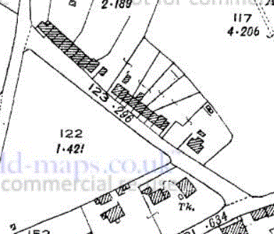
The Green and the properties photographed below on the 1876 1:2500 OS map Old-maps.co.uk
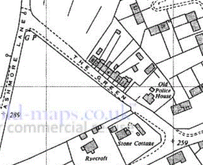
By 1926 the new building had been replaced by the house that is now Pounces Cottage. This map shows the configuration of buildings captured so effectively in the photographs below.
The Green on the 1926 OS map - Pounces Cottage has been added Old-maps.co.uk
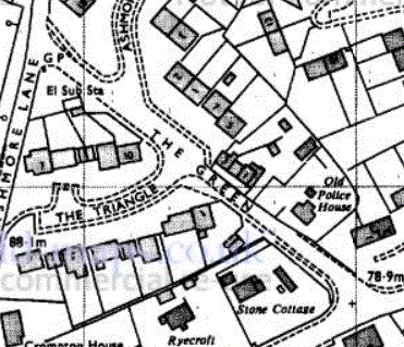
By 1966 the thatched cottages to the north had been demolished ready to build Ashmore Close. Pounces Cottage is labelled as the "Old Police House".
The Green on the 1966 OS map, showing Pounces Cottage as the "Old Police House" Old-maps.co.uk
By 1978 the scene is looking much more familiar, with Ashmore Close having been built. Pounces Cottage to the south (Old Police House) is still separated from Ashmore Close by the original terrace of houses. This terrace had been shortened from eight to three houses to fit in the Ashmore Close bungalows that lie along the line of The Green.
The Green on the 1978 OS map, showing Pounces Cottage as the "Old Police House" Old-maps.co.uk
The WI scrapbook, started in 1957 and held for many years by Mrs Hammond, preserved an interesting set of photographs of these developments, shown below. I've added modern (2019) photographs to provide a reference for each picture. Mrs Hammond was the wife of the butcher and churchwarden Hedley Hammond and the north gate to the churchyard opposite their house (Southdown) was erected in their memory (see All Saints Church for a photograph of the memorial plate).
The first picture below is a postcard taken looking down The Green from the junction with Ashmore Lane, the nearer row of cottages stood across the space where Ashmore Close now stands. There is a picture of the same cottages taken from the other end further down this page. Beyond these cottages is the row of cottages that stood opposite The Triangle until around 1990-5. I also have a photograph (slide) of Kemish's house in that row with his signboard announcing "Kemish - Carrier" - find it and add here. Two houses, one in front of the other, stand on that site now [2016]. Beyond that row the roof and chimneys of Pounces Cottage can just be seen and behind that the building on the far side of Romsey Road at the junction, converted in recent times (post 1990) to the house Hay Barn. These various houses and terraces can be seen in different views in the photographs that follow this one. There are lots of copies around, some showing more of the scene, others more detail, so I've put a selection of three here. Right click and select "open in new tab" to see a larger copy.
.jpg)
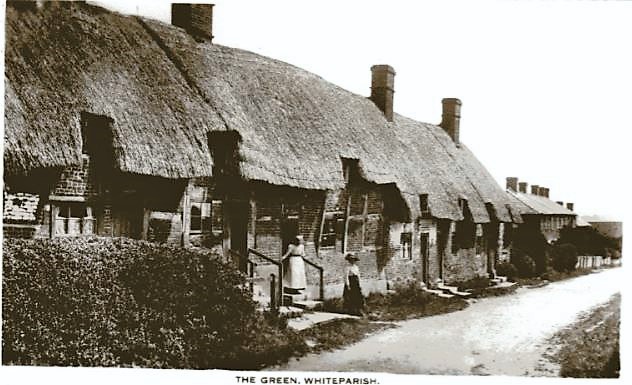

There are many versions of this postcard of The Green looking down towards the A27 from the junction with Ashmore Lane
The central (larger) copy here preserves more of the original photograph
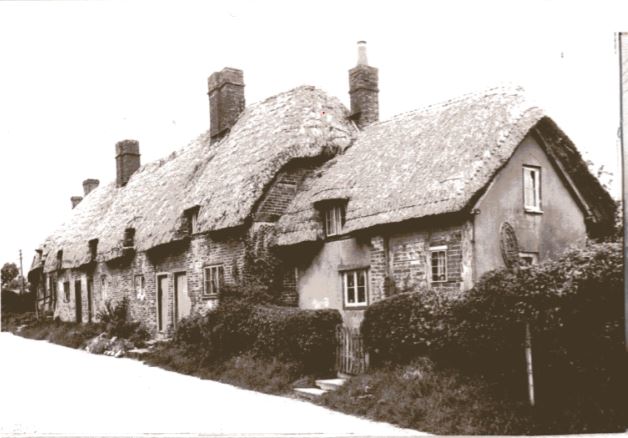
The next photograph shows the back of the same cottages and the rearward extension of some, with their extra chimneys. I've yet to find an explanation for the large heap at the right edge of the picture. This photograph suggests that either some of the cottages were built at different dates, or else had been modified subsequently. The view above of the front of the buildings suggests a different division of the row into two styles of house.

A rear view of the thatched cottages on The Green and their gardens
The next picture shows the same row of thatched cottages, looking up the hill from somewhere near where the entrance to The Triangle is now. In this picture the houses with a lower front edge to the thatch and the first four dormer windows dominate the view, with the ones further up the hill less obvious. Compare with the views above. In the same way the nearer house, slightly lower and set back from the others, doesn't show at all in the picture above taken from the Ashmore Lane junction. The 1926 map suggests a row of four houses at the top of the road (north), then a set of three (with the slightly lower thatch at the front), and finally the one set back from the others at the south end.
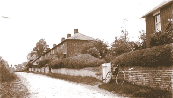
The houses east of The Green taken from the other end (from the WI scrapbook)
Two modern photographs below show the bungalows of Ashmore Close that replaced the thatched cottages and five of the slate roofed ones that stood in the terrace opposite Meadow Court.
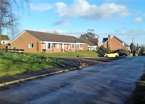
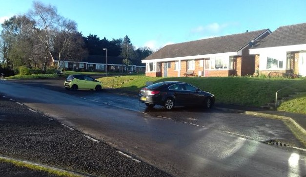
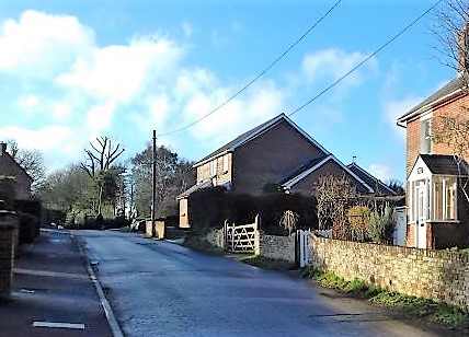
The same location in March 2019
The same scene in March 2019
This is followed by a picture of the more distant terrace in the first photograph, with slate roofs, with Pounces Cottage in the foreground, taken from close to the A27 Romsey Road. These houses were there until more recently, being demolished to make way for the present houses around 1990. Pounces Cottage is still there [2022].
The houses east of The Green from near the A27, Pounces Cottage in the foreground (from the WI scrapbook)
I've attempted to reproduce exactly the same view in the modern photograph that follows, again with Pounce's Cottage in the foreground.
The same scene in March 2019
Finally there is an iconic picture of the thatched cottages being burnt prior to demolition in order to build Ashmore Close in its present form, from the WI scrapbook in the 1980s, kept at that time by Patricia Keeley (now Boyle).
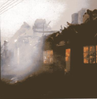
The thatched cottages east of The Green being burnt by the council ready for demolition (from the WI scrapbook)